Posts about Nature

Experience the natural beauty of Yogyakarta, where dramatic landscapes and peaceful countryside create unforgettable moments. Discover ancient volcanoes like Mount Merapi, explore lush rice fields and hidden waterfalls, or relax along the stunning beaches of Gunungkidul with their crystal-clear waters and limestone cliffs. Adventure seekers can enjoy cave tubing, hiking, and sunrise viewpoints, while nature lovers can immerse themselves in quiet village life and scenic rural trails. Yogyakarta’s diverse landscapes offer the perfect balance of adventure, tranquility, and breathtaking views.

Tambora : A volcanic explosion that changed the world

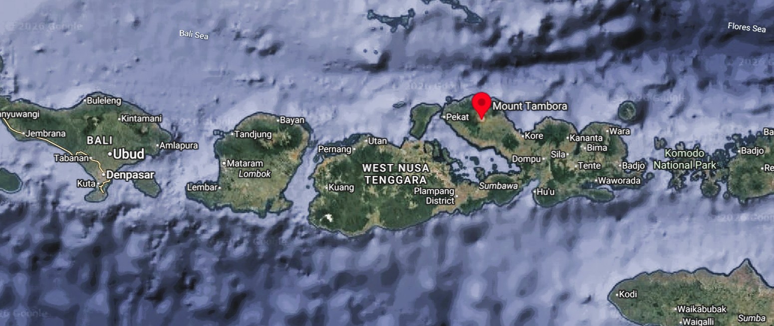
Today, April 10, 2026, the world commemorates 211 years since the peak eruption of Mount Tambora on Sumbawa Island shook human civilization.

In 1815, this volcanic activity reached its most devastating phase, sending ash 32 kilometers into the atmosphere and flowing molten rock that incinerated surrounding villages.

The explosion is recorded as the most powerful eruption in human history, ranking at a seven out of eight on the U.S. Geological Survey’s Volcano Explosivity Index.

The impact not only destroyed local geographic maps but also altered the physical structure of the mountain, shrinking it from a height of 14,000 feet (4,267 meters) to just 9,000 feet (2,743 meters).

Although thousands died instantly from pyroclastic flows, history records that the true horror began when the volcanic ash spread across the globe.

A crucial question arises behind this grim record: did secondary impacts such as climate change and epidemics actually claim far more lives than the explosion itself? How could an eruption in the Dutch East Indies (now Indonesia) create a “year without a summer” in other parts of the world?


Mount Tambora map
Mount Tambora map (163 km from Komodo Island)

The Chain of Death from Crop Failure to Global Pandemic

Data from History and National Geographic shows a stark difference between the number of direct and indirect victims.

Instantly, approximately 10,000 to 12,000 people on Sumbawa Island died from pyroclastic flows, toxic gases, and a moderate tsunami triggered by the collapse of the volcano.

However, in the following months and years, the death toll skyrocketed, reaching an estimated 71,000 to 121,000 in the surrounding region due to post-eruption starvation and disease.

Gillen D’Arcy Wood, author of Tambora: The Eruption That Changed the World, cites even more dire figures when considering the long-term global effects.

The “Year Without a Summer” in 1816 saw severe climate abnormalities, including summer frosts and snow in New England and Europe, caused by the 1815 eruption of Mount Tambora in Indonesia. This volcanic winter led to widespread crop failures, famine, and food riots across the Northern Hemisphere.
Key Facts About 1816:
    • Cause: The April 1815 eruption of Mount Tambora was the most powerful in recorded history, releasing massive amounts of ash and aerosols into the atmosphere that dimmed the sun.
    • Global Impact: Average global temperatures dropped by 0.4 – 0.7ºC (0.7 – 1.3ºF)
    • Regional Effects:
      • North America: Snow was reported in June in New England, and frost persisted through summer, destroying crops.
      • Europe: Cold, rainy weather led to massive crop failures and the “last great subsistence crisis” in Western history.
      • Asia: The monsoon season was disrupted, causing floods, while in China and Taiwan, cold weather/snow was reported, causing famine in Yunnan.
  • Historical Impact: The famine and economic hardship sparked food riots and, in Germany, encouraged Karl Drais to develop the “running machine,” a forerunner to the bicycle. The gloomy weather also inspired Mary Shelley to write Frankenstein.
  • Duration: By 1817, the atmosphere had cleared and weather patterns largely returned to normal


Read other posts about mountains here

Sikunir, the golden sunrise in Dieng

Sikunir Hill is a tourist attraction located in Sembungan Village, Kejajar District, Wonosobo Regency. It sits at an elevation of 2,300 meters above sea level. It also offers a variety of mountain views directly visible from the summit, including Mount Sindoro, Mount Prau, Mount Sumbing, Mount Merbabu, Mount Merapi, Mount Lawu, Mount Slamet, and other mountainous areas, all visible on clear days.

One of the most captivating panoramas is the golden sunrise. It was once said to be the best in Southeast Asia. To enjoy the beauty of the golden sunrise, visitors are advised to climb between 4:00 and 5:00 a.m. Sikunir Hill also has a camping area for tourists who want to linger longer.


Climbing Sikunir

Climbing Sikunir Hill is relatively easy, thanks to the well-maintained footpath. There’s also access through stairs, equipped with iron handrails to prevent slipping while ascending or descending. Safety guards and signage leading to the summit are provided along the path.

Although it may seem easy, tourists should not underestimate the climb. The trail requires good physical condition. Visitors are advised to wear a jacket, gloves, or head covering to ward off the piercing cold. They can also bring snacks to enjoy along the way.

The climb to Sikunir Hill takes approximately 30 to 45 minutes. For climbers who prefer a leisurely pace, the climb will take about an hour. The exhaustion of the climb is rewarded by the view of the golden sunrise that greets visitors at the summit of Sikunir Hill.

The glowing golden hues in the sky will erase fatigue and make visitors reluctant to leave. The summit of Sikunir Hill is quite wide, so climbers don’t have to worry about crowds. Another panoramic view directly below Sikunir Hill is Telaga Cebong.

Dieng Telaga Cebong
Dieng – Telaga Cebong

The best time to climb Sikunir Hill is during the dry season, especially from June to September, when the weather is clear and the chances of seeing the Golden Sunrise are highest. The ideal time to climb is from the Telaga Cebong parking area at 3:30–4:00 a.m. WIB to reach the summit before sunrise, around 5:30 a.m.

2010 Merapi eruption, the biggest in a century

No one expected the 2010 Merapi eruption would be so devastating. Residents along the slopes of Merapi were accustomed to eruptions.

They had lived with them for decades, with eruptions occurring almost every year-round. But in 2010, Merapi erupted millions of tons of hot material, its largest eruption in 100 years.
The government at the time had ordered all residents within the danger zone to evacuate.

The 2010 Mount Merapi eruption caused many deaths due to several powerful and unexpected volcanic hazards around Mount Merapi.

Extremely Powerful Eruption

The 2010 eruption was one of the largest in over a century. Explosive blasts sent ash clouds and volcanic material high into the atmosphere.

Merapi eruption 2010

Deadly Pyroclastic Flows

The most dangerous factor was pyroclastic flows—super-hot clouds of gas, ash, and rock moving up to 100 km/h.
Temperatures can exceed 600°C, destroying everything in their path.


Larger Danger Zone Than Expected

Scientists initially estimated a smaller danger zone, but the eruption became much stronger, sending pyroclastic flows farther than predicted, reaching villages outside earlier evacuation areas.

Some Residents Refused to Evacuate

Some people stayed behind to protect homes, farms, and livestock. Others trusted spiritual guardians like Mbah Maridjan, who also died during the eruption.

Dense Population Around the Volcano

Thousands of people live on the fertile slopes of Merapi because volcanic soil is very good for farming. This high population density increased casualties.

Nighttime Eruptions

Several major eruptions occurred at night, when evacuation and visibility were more difficult.

What you need to know before visiting Karimunjawa

Karimunjawa Islands offers a tropical escape with clear waters, white-sand beaches, and rich marine life in the Java Sea. These are things you need to know before visiting Karimunjawa


Best things to do in Karimunjawa

Snorkeling and diving
Karimunjawa has some of the clearest water in Java. Explore coral reefs and tropical fish around Menjangan Kecil Island and Cemara Kecil Island. You may see clownfish, sea turtles, and colorful coral gardens.

Snorkeling Karimunjawa


Island Hopping
You can take boat tours to take you around the islands inside Karimunjawa National Park. Popular stops include Menjangan Besar Island and Geleang Island.

  1. Best Sunset Spots
    Enjoy the best sunset spots in Tanjung Gelam Beach and Bukit Love Karimunjawa.

    Sunset Tanjung Gelam - Karimunjawa
    Sunset Tanjung Gelam, Karimunjawa
  2. Visit Turtle Conservation
    If you take boat tours to Menjangan Besar Island, there you can also visit turtle conservation and sometimes swim near them.
  3. Mangrove and Nature tours
    Walk through the mangrove forest boardwalk at Karimunjawa Mangrove Forest.

How to get to Karimunjawa

From Yogyakarta, you can optionally go with a private car or a shuttle car to Kartini beach. Private car offers a more flexible and faster timing, so you can arrive not so long before the ferry departure. The shuttle car is more economic but doesn’t have perfect timing or you will need to rent a room. Then you take a fast boat Express Bahari for 2 hours or Ferry Siginjai for 4-5 hours.

When to visit Karimunjawa

April to October is best time to go to during the dry season and the waves is not high. It’s strongly suggested you take 3 days 2 nights in Karimunjawa to be able to explore most of the spots. Avoid December – February for the waves and ferry cancellations happen a lot. Snorkeling and diving is best during May and September.


Get your Karimunjawa tours here

Best sunset spots in Yogyakarta

Yogyakarta has some best sunset spots that offer warm and relaxing vibe with beautiful landscapes. Here are 4 best sunset spots in Yogyakarta recommended by jogjatripper.


Prambanan temple

Prambanan temple is one of the most beautiful temples in Yogyakarta. The main temple towers 47 meters above several other temples, making it even more beautiful with a stunning sunset backdrop. You can continue this sunset tour by watching a Ramayana dance performance in the same area. Get  Prambanan temple sunset combined with Ramayana ballet here.

Prambanan sunset


Plaosan temple

Plaosan temple lies not far from Prambanan temple and perfect for a sunset because it’s not so crowded. Also known as the twin temple, which are almost symmetrical. This rare layout makes it stand out among other temples in Java. Plaosan beautifully combines Buddhist design with Hindu influences. It reflects religious harmony during the 9th century in Central Java. Get Get Prambanan temple, Plaosan temple and Kotagede heritage site here.

Plaosan silhouette
Plaosan silhouette


Ijo temple

Candi Ijo is the highest temple in Yogyakarta, making it one of the best spots to enjoy a serene sunset. Several smaller temples are located on the hillside, amidst the tranquil surroundings, from which you can see Prambanan Temple and the city of Yogyakarta in the distance. Get a tour for Ijo temple sunset combined with Ramayana ballet show here.

Candi Ijo


Bukit Watugupit

Bukit Watugupit is a favorite spot for enjoying the sunset with a partner or group, overlooking the Parangtritis coastline. It’s also a paragliding launch point, making the sunset even more special. You can enjoy waiting for the sunset with coffee and a selection of traditional snacks at Shoka Bukit Senja.

Paragliding on Watugupit


Pine Forest Mangunan

Pine Forest Mangunan is perfect for selfie lovers. A stunning background of Yogyakarta city with all the lights can bring a vibrant photos with unique selfie spots made of tree branches.

Pine forest photo sunset in Yogyakarta
Pine forest

Best sunrise spots in Yogyakarta

These are 3 best sunrise spots in Yogyakarta recommended by jogjatripper that will boost your mood and energy level.

Borobudur
Borobudur temple offers a sunrise experience like no other. Imagine yourself standing on the top of the biggest Buddhist temple in the world in a quiet and peaceful dawn with the background of valleys and mountains in a distance. It instantly makes you feel like go back to the ancient time. Get an exclusive Borobudur sunrise and Prambanan tour here.

Borobudur sunrise


The hill nearby Borobudur
There are two hill sunrise spots : Punthuk Setumbu and Barede Hill. Overlooking Borobudur about 2 kilometers away, both hills offer the same beauty. While Punthuk Setumbu is more famous that’s also more crowded, Barede has less visitors. Get a Borobudur sunrise tour from the hill here.

Sunrise near Borobudur


Merapi volcano
Merapi volcano is the most active volcano in Indonesia up until today. The sunrise spot is around 5 km away from the summit, near the bunker. This is included with Jeep tour that visits the bunker and the mini museum which was a house destroyed by the big eruption in 2010. Get a magnificent sunrise volcano tour here.

Merapi sunrise

What to prepare in Jomblang cave

Jomblang cave has become a unique natural attraction and one of a kind in Indonesia. Foreign tourists from Singapore, Malaysia, China and various European countries visit Jomblang Cave every day. Limited to only 100 people per day, visitors come to look for the heavenly lights.

Visitors descend the cave with a depth of 60 meters and a width of 80 meters using a rope that can withstand a load of 1000 kg and another rope as a safety backup. The experienced Jomblang cave team slowly lower every 2 people then pull you up afterward.

After arriving at the bottom, visitors walk through the darkness of the cave for 300 meters, heading to Grubug Cave where the heavenly light shining down between the gaps in the mouth of the cave.

Here are things that visitors need to prepare:

  1. Compact and comfortable clothing
    The muddy and slippery conditions of the cave require clothing that makes you move comfortably.
  2. Eat and drink
    You will be in the cave for around 2 hours in a humid and pretty difficult terrain, so having enough food and drink before entering it is necessary.
  3. Flashlight or headlamp
    The middle of the cave is completely dark.
  4. Bottled drinking water
    Jomblang Cave is very humid inside. This may make visitors easily feel tired and thirsty
  5. Camera or cellphone
    A camera or cellphone that has good low-light capabilities will make beautiful photos inside the cave. You surely don’t want to miss a chance to get good pictures with the ray of light shining on you.
  6. Socks
    A pair of sock prevent your ankles from being scratched by the boots

jomblang cave ray of light jomblang cave walk in the dard

Get a Jomblang cave and Pindul cave tour here.